Major Incident Archive

The Rancho Santa Fe Fire Protection District wishes to thank everyone for the outpouring of support and gratitude during the Bernardo Fire. The generous gifts of food, cards, beverages, and more, while not necessary, were much appreciated. We’ve been so flooded with goodies and kindness that we ask that any future donations be made to the Red Cross, which aids both firefighters and displaced families.
We would also like to thank the other agencies with whom we worked so closely during the incident. It truly was a joint effort with Del Mar, Elfin Forest, Encinitas, Oceanside, Poway, Rainbow, San Diego, San Marcos, Solana Beach, and Vista Fire Departments, CalFire, U.S. Forest Service, San Diego County Sheriff’s Department, San Diego Police Department, and the State Office of Emergency Services. We also appreciate all of the fire agencies from outside our local area who came to assist not only with the Bernardo Fire but the other incidents in our area as well. A special thank you, too, to the dispatchers at North County Dispatch JPA.
Finally, thank you to our families, some of whom were evacuated themselves. We couldn’t do what we do without your love and support.
On Tuesday, May 13, 2014, a fire broke out near the community of 4S Ranch. By the time it was 100% on Saturday, May 19, 2014, the fire burned 1548 acres. No homes were destroyed. Below is the blog we maintained on our website during the event. We also provided updates on the nearby Cocos Fire as it threatened to burn into the RSFFPD's service area.
FINAL UPDATE: May 19, 2014, 8:15 a.m. – The fire was 100% contained as of 6 p.m. on Saturday, May 17. In total, over 200 fire personnel responded to the Bernardo Fire, which burned 1548 acres and threatened 50 structures but none were lost. It was accidentally caused by power equipment use.
May 16, 2014, 8:52 a.m. – The fire is now 90% contained and fire crews are in final mop up stages.

May 15, 2014, 8:00 p.m. – There is no new information on this incident this evening. There are crews still on scene to ensure there are no new flare ups.
May 15, 2014, 7:53 a.m. – The Bernardo Fire is now 75% contained. As you can see in the distance in the photo, crews are still in area continuing containment and mop up efforts. (Click for larger photo.) Additionally, the Cocos Fire is not an immediate threat to the district but we are monitoring the situation.
May 14, 2014, 5:28 p.m. – The Bernardo Fire remains at 1548 acres and is now 50% contained. Some resources are starting to be released to assist with other incidents. Crews will remain on scene to ensure the fire is completely out. There are no other incidents in the district at this time.
May 14, 2014, 3:30 p.m. – There are no evacuations for the Rancho Santa Fe Fire Protection District at this time; however, residents are encouraged to stay alert.
May 14, 2014, 11:53 a.m. – The Bernardo Fire is now over 1500 acres and 25% contained. Forward progress has been stopped but the threat is not over. Fire crews remain on scene working to aggressively attack the perimeter, maintain control, mop up hot spots, and contain the fire. No evacuations are in place at this time but residents are urged to be alert and prepared for possible future evacuations.
May 13, 2014, 8:00 p.m. – As of 8:00 pm tonight, evacuated residents are allowed back into their homes. We urge all residents to remain on alert and ready to evacuate should the fire flare up again. As of this evening the fire has burned 800 acres and is 5% contained with fire activity quieting down.
FINAL UPDATE: May 22, 2014, 6:30 p.m. – Per CalFire, the Cocos Fire is now 100% contained.
May 19, 2014, 8:05 a.m. – The acreage for the Cocos Fire has been reduced to 1995. It is now 89% contained and no longer a threat to the Fire District. Also, all evacuations have been lifted for this incident.
May 16, 2014, 8:52 a.m. – The Cocos Fire is now 3,018 acres and 10% contained. Evacuations remain in place but the evacuation orders for Mt. Israel and Del Dios have been lifted. Fire crews are aggressively working in areas of concern, including the Harmony Grove area near our Fire District. While it came close yesterday, the fire has not crossed into the Fire District.
May 15, 2014, 10:50 p.m. – The evacuations for Mt. Israel and Del Dios have been lifted.
May 15, 2014, 8:00 p.m. – The Cocos Fire is now 1,200 acres and 5% contained. While the flames and smoke have died down a bit, Mt Israel and Del Dios remain under evacuation. Law enforcement is patrolling the area while fire crews continue to work to control the fire.
May 15, 2014, 3:28 p.m. – For those in our Shelter-in-Place communities, sheltering should be a last resort only. If you are told to evacuate, do so immediately.
May 15, 2014, 2:10 p.m. – The RSFFPD is issuing an evacuation order for the communities of Del Dios and Mt. Israel. Reverse 911 calls will be going out shortly.
May 15, 2014, 11:00 a.m. – While the Cocos Fire (San Marcos) is not an immediate threat to our District, we are monitoring the situation and will be providing updates on its progress. Currently, the fire is 800 acres and 5% contained. The east side of the fire is heading toward Harmony Grove. More information can be found on CalFire's Cocos Fire incident page.
General Information
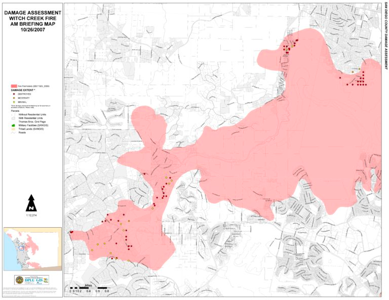
The Witch Creek Fire broke out shortly after noon on Sunday, October 21, 2007, near Ramona. The fire, aided by strong Santa Ana winds and plenty of extremely dry fuel, spread quickly and reached the Rancho Santa Fe Fire Protection District boundaries at approximately 1:30 a.m. on October 22 and the entire population of the District was evacuated at 10:30 that morning. Rancho Santa Fe firefighters, with the help of strike teams from Northern California as well as other local agencies, spent several days fighting active fire and providing structure protection throughout the District, achieving full containment on October 24. Residents were allowed back in their homes shortly before noon on Friday, October 26, after Fire District and Sheriff's Department officials confirmed the area was clear of spot fires and road obstacles.
Quick Statistics (from within the Fire District boundaries)
- Approximately 6,000 acres burned
- 61 homes/outbuildings destroyed
- 23 homes/outbuildings damaged
- 21,000 evacuated
- No significant injuries or deaths
Damage Assessment
The following is a list of structures that were damaged or destroyed by the fire. If you believe there is an error on the list, please contact the Fire District, 858-756-5971.
Damage Assessment List of Damaged or Destroyed HomesThere are NO structure losses within the communities of:
- 4S Ranch (tracts)
- The Bridges
- Cielo
- The Crosby
- Mount Israel
Maps
Progression Map

Preliminary Damage Assessment Map (Rancho Santa Fe only)

